
Material Conditions
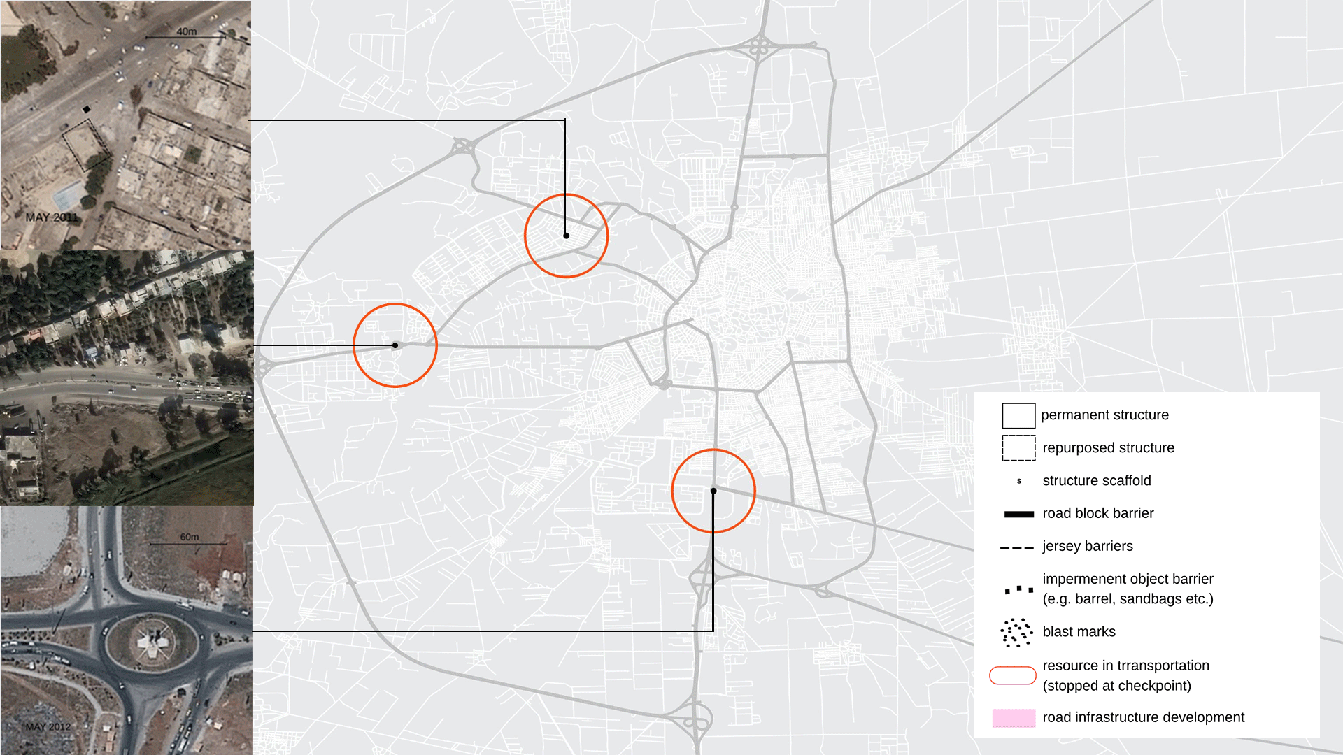
Checkpoints are material expressions of control. Therefore, modelling checkpoints is a way to showcase the growth and spatial imprint of these ephemeral and fixed structures in the context of a city. By elaborating the territorial occupation in the urban areas under regime control, we can identify the way the checkpoints were operating and the architectural elements that constituted them, as well as their evolution through time. We are building here on research done e.g. by SNHR to classify elements of checkpoints1.
Checkpoints in Syria have a wide range of lifespans and materialisations: “flying” checkpoints might be staffed by a handful of soldiers for a few days, with no infrastructure beyond chairs and the soldiers’ own weapons. We looked at checkpoints that solidified into permanent infrastructures akin to toll plazas, variably composed of roadblocks, lane dividers, and covered sheds. Out of these, we extracted the typology.
Material typologies: The checkpoints’ physical structures
Methodology: Historic analysis as starting point for spatio-temporal analysis
Early in the Syrian conflict2, Homs swiftly emerged as the symbolic and operational heart of the uprising3. Faced with the regime’s violent repression, residents constructed and circulated informal maps of regime checkpoints4, most notably through the now-defunct ‘Community Walk’ platform, preserving a local archive of occupation as it unfolded. From this corpus, and drawing on cross-referenced satellite imagery and ground testimony, we identified checkpoints that persisted beyond the early stages of the conflict, ultimately crystallising into fixed militarised infrastructures.
Three sites were selected to represent the trajectories of checkpoint development:
- one demonstrates a fixed, evolving checkpoint infrastructure (Case study 4),
- one hybrid example (Case study 5), and
- one is an example of flying checkpoint infrastructure (Case study 6)
These selections allow us to move beyond narrative or testimonial accounts toward a forensic architectural reading. For each case, we modelled the physical footprint observable in satellite imagery and extruded it into three-dimensional space using height estimates drawn from ground photographs and videos. This process enabled visual reconstruction of spatial sequences, operational zones, and phased evolution. The resulting models serve both as analytic devices and archival artefacts: tools capable of revealing the incremental accretion of checkpoint authority and the socio-political economy through which it operated.
Case study 4: The farm checkpoint in Al-Mazraa
The “farm” (حاجز المزرعة) or “roundabout” checkpoint on the M1 highway west of Homs is an instructive example of how checkpoints evolve to serve different functions over the course of the conflict. Specifically, Al-Mazraa, located at Homs’ primary entry point for coastal traffic from the M1, illustrates our earlier point how military checkpoints leveraged their control of key economic corridors as the conflict waned or moved to new frontiers. Apart from its military object next to Al-Wa’er, we see it mentioned in the seizure of smuggled sugar5, ID checks to prevent entry or collect levies6 and kidnappings7 during the siege of Al-Wa’er. While we focus on the western most gate with two structures, the north and east entrances to the roundabout as well as the west exit also have smaller checkpoints with concrete barriers. From satellite imagery, we can identify traffic jams indicating a checkpoint under a tree since early 2011. We can track its changes as follows:
Reinforced with concrete jersey barriers.
(Initial reports of vehicle inspections)

Reduced to a mobile stop at the roundabout entrance.

The road lanes are separated, and a second checkpoint is added on the same stretch of road.

New concrete barriers installed
Expanded into final shape, with reinforcements and extensions to supporting administrative buildings.
Imagery ©2025 CNES / Airbus, Maxar Technologies, Map data ©2025 Google
The construction of the checkpoint in early 2011 correlates with the beginning of the siege of Homs, and it doesn’t change during the fall of Baba Amr (bordering south of Al-Mazraa) in 2012. The reduction in 2014 may be related to the end of the siege on Al-Wa’er (bordering north of Al-Mazraa), our case study 2 but, crucially, reinforcements are introduced after the siege in 20178, suggesting it had developed an economic objective by this point. Between the end of the main siege and fall of Wa’er it frequently changed hands depending on the stage of conflict, with contradictory reports ranging from Shiite army fractions9 to shifting jurisdiction of the forth division10 11, and even Hezbollah12. Until recently, we can see the brick structure and concrete barriers of the west still present, however the military presence appears reduced and it’s unclear if they are still operating as checkpoints:

Whilst attacks on checkpoints still occurred, potentially warranting military presence13, the militarisation of such checkpoints might be better understood part of the “war economy”14. In this way, checkpoints can be used to “control access to business opportunities, exerting power over commercial sectors”15. During this period, multiple sources corroborate a pattern of hostage-taking16 and arbitrary detention17, property seizures18, and threats of arrest. The New Lines Institute writes that “this practice … in Homs in 2013, had come to solely benefit the 4th Division and its paramilitary and business brokers”19. It is therefore likely that the military effectiveness, combined with the shifting power dynamic after the siege of Homs, contributed to the commercialisation of the checkpoint, both indirectly, in terms of control of flows, as well as direct revenue source.
Case Study 5: Tadmur Gate
The Tadmur Roundabout positioned at the southern entrance of Homs where the M5 and N3 highways intersect illustrates how checkpoints in Syria transition from temporary posts into fortified infrastructures. The strategic location is a gateway for logistical flows between Homs, Damascus and the country’s eastern provinces made it a priority site for regime securitisation at the onset of the war. Local testimonies20, corroborated by satellite imagery, indicate that inspections commenced at this junction in late 2011 soon after anti-government mobilisations intensified in the city.
In its initial configuration, the checkpoint appeared as a rudimentary arrangement of steel drums and sandbags. This temporary measures, typical of rapid military deployment, was nonetheless effective in disrupting mobility and asserting regime presence. By late 2012, concrete traffic dividers, covered sheds and observation points materialised, marking a critical development from a makeshift military posture to a permanent apparatus of territorial control. Ground footage from early 2013 shows that one of the sheds was painted with portraits of Bashar and Maher al-Assad, signifying an ideological alignment with Fourth Division authority21, demonstrating an entanglement of symbolic governance and infrastructural violence.
Satellite imagery from 2016 confirms further reinforcement and consolidation. Temporary barriers were replaced with organised lanes and permanent canopies, funnelling vehicles into narrowly controlled pathways. Overall, the architectural evolution of the Tadmur Roundabout charts the gradual conversion of militarised emergency measures into durable infrastructures of authoritarian governance and profiteering.
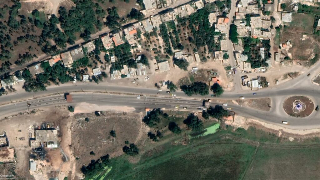
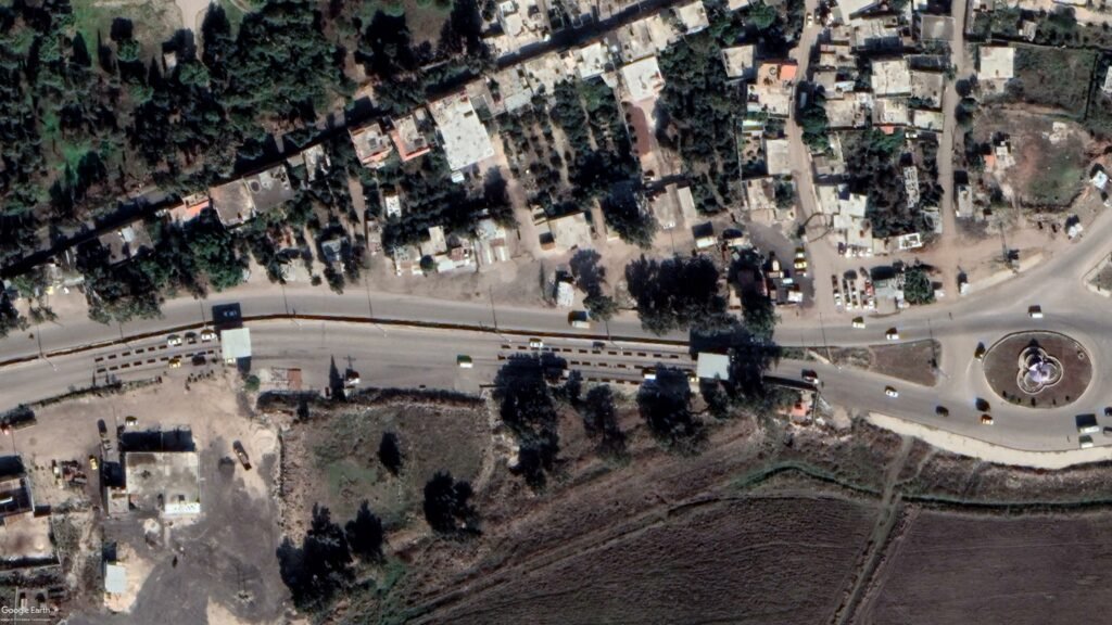
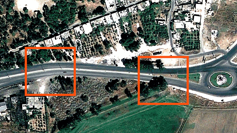
Case study 6: Fire station
The fire station checkpoint in the Wa’er district demonstrates the operational logic of flying checkpoints – temporary, opportunistic forms of territorial control embedded within civilian life. Wa’er, the last major opposition-held enclave in Homs, was encircled by regime forces from 201122 until its capitulation in 2017. During this period, the state appeared to deploy mobile checkpoints throughout the neighbourhood to fragment internal mobility and suppress collective organisation23.
A flying checkpoint occupied a municipal fire station in Wa’er. Footage from mid-201124 to late-201125 shows how state security forces appropriated the existing building, barricading entrances with sandbags and positioning snipers on the roof. Firing apertures cut through stacked sandbags and reinforced firing points facing the adjacent Shukri al-Asali Street, the district’s main artery, were removed in 201526. Across the road, additional snipers were positioned atop Al-Bar Hospital creating intersecting lines of fire that controlled civilian circulation and facilitated military sightlines.
Despite local witness reports27 and ground footage even in 201228, the architectural footprint of this checkpoint is almost invisible in satellite imagery, an absence that underscores the analytic challenge of identifying flying checkpoints using remote methods alone. Only through triangulating activist footage, eyewitness accounts and spatial orientation could we locate and verify its position. Its invisibility was not incidental: the fire station checkpoint operated through sudden mobility, intimidation, and the appropriation of civic facilities. Rather than announcing itself as a border, it blurred the boundary between civilian infrastructure and military surveillance, creating an environment of uncertainty29.
In this sense, the flying checkpoint reveals a critical dimension of Syria’s wartime spatial regime: coercion does not solely operate through fortified nodes but through transient occupations of everyday space that can render the city a machine of control.
- Syrian Network for Human Rights. “Types of Checkpoints Used by the Syrian Regime to Besiege and Arrest Citizens.” Syrian Network for Human Rights, 2013. ↩︎
- Tarabay, Jaime. “For Many Syrians, the Story of the War Began With Graffiti in Dara’a.” CNN, March 3, 2018. ↩︎
- Harkin, James. “Homs: Inside the City at the Heart of Syria’s Rebellion.” The Guardian, November 19, 2011. ↩︎
- Homs Community Walk in Wayback Machine, 2012. ↩︎
- Syrian Arab News Agency (SANA), “مصادرة خمسة أطنان من السكر معدة للتهريب بحمص.“ ↩︎
- Zaman Alwasl. “Car Bomb Rocked Al-Mazra’a Checkpoint in Homs.” Zaman Alwasl, July 30, 2013. ↩︎
- Al-Araby Al-Jadeed. “حيّ الوعر الحمصي… من الحصار والتهجير إلى ‘التسوية’.” Al-Araby, November 9, 2022. ↩︎
- Aljumhuriya. “الوعر: الثورة، الحصار، التهجير” الجمهورية نت, October 8, 2017. ↩︎
- Enab Baladi. “تعرف على أبرز وأخطر الحواجز العسكرية في مدينة حمص.” Enab Baladi, September 23, 2016. ↩︎
- Aawsat. “إزالة حواجز للفرقة الرابعة بشكل مفاجئ في مناطق سورية.” Aawsat, September 5, 2023. ↩︎
- Syria TV. “قرى حمص تنتفض على حواجز “الفرقة الرابعة” بعد مقتل شاب.” Syria TV, October 8, 2021. ↩︎
- Soldiers appear to wear fourth division shoulder markings.
AlHadath. “”إدارة العمليات العسكرية” تنفذ مداهمات في قرية المزرعة “أحد معاقل حزب الله.” Youtube, December 15, 2024. Accessed November 9, 2025. ↩︎ - Zaman Al-wasl. “سيارة مفخخة تنفجر على حاجز المزرعة والنظام يرد بقصف وعر حمص.” Zaman Alwsl, July 29, 2013. ↩︎
- Niang, “The War Economy.” ↩︎
- UN-Habitat. Recovery of Services and Infrastructure in Syria. “Not If, But How?” Urban Recovery Framework, 2022. ↩︎
- Syrian Network for Human Rights. A Dreadful Homecoming: Widespread Human Rights Violations against Syrian Refugees Returning from Lebanon. Syrian Network for Human Rights, 2024. ↩︎
- Enab Baladi, “تعرف على أبرز وأخطر الحواجز العسكرية في مدينة حمص,” Enab Baladi, September 23, 2016. ↩︎
- PAX & The Syria Institute. Siege Watch: Final Report. Utrecht & Washington DC., 2018. ↩︎
- New Lines Institute for Strategy and Policy. Intelligence Briefing: Syria’s Fourth Division. Washington, D.C.: New Lines Institute, 2023. ↩︎
- Homs Community Walk, 2011. ↩︎
- Enab Baladi, “تعرف على أبرز وأخطر الحواجز العسكرية في مدينة حمص.” ↩︎
- BBC News. “Homs: Syrian revolution’s fallen ‘capital’” BBC News, December 9, 2015. ↩︎
- Syrian Network for Human Rights. The continuing siege of “Daraya” and “Al Wa’er Neighborhood”: Repeated Violations of the Cessation of Hostilities and the Security Council Resolutions. Syrian Network for Human Rights, April 27, 2016. ↩︎
- SyrianGhostFreedom. “حمص حواجز ومتاريس الجزء الثاني لمناطق الوعر والسوق والمدخل الشمالي مع هدية العدد.” YouTube, August 29, 2011. ↩︎
- Syrian2011X. “FW: حمص الوعر حاجز الإطفائية 6-11-2011.” YouTube, November 6, 2011. ↩︎
- حمص الوعر أول ب أول. “Photo 1536752973282140.” Facebook, November 3, 2015. ↩︎
- Homs Community Walk, 2011 ↩︎
- ShaamNetwork S.N.N (شبكة شام الإخبارية).”Sham Homs Al-Waer checkpoint, Al-Bir Hospital, third gate, 17/5/2012.” YouTube, May 18, 2012. ↩︎
- Schon, “The Centrality of Checkpoints,” 281-310. ↩︎